
Tropical cyclones almost never form over the Strait of Malacca. The narrow waterway separating Peninsular Malaysia from the Indonesian island of Sumatra sits so close to the equator that the Coriolis effect is usually too weak to allow storms to rotate enough to organize into cyclones. But on November 25, 2025, meteorologists watched as a tropical depression intensified into Cyclone Senyar—just the second documented case of a tropical cyclone forming in the strait.
Hemmed in by land on both sides, Senyar made landfall in Sumatra later that day as it made a U-turn and headed east toward Malaysia. As the slow-moving storm passed over Sumatra’s mountainous terrain, it dropped nearly 400 millimeters (16 inches) of rain in many areas, according to satellite-based estimates from NASA’s Global Precipitation Measurement (GPM) mission. (Due to the averaging of the satellite data, local rainfall amounts may differ when measured from the ground.)
The torrent caused extensive flash floods and landslides in Sumatra’s rugged terrain. Streams and rivers rapidly overflowed with sediment-laden, debris-filled waters that swept through villages, cities, and towns. News reports suggest that the damage was worsened by an earthquake that struck on November 27 and the abundance of loose piles of timber in the region that became destructive battering rams in high water. As of December 4, Indonesian authorities reported several hundred deaths and more than 700,000 displaced people.
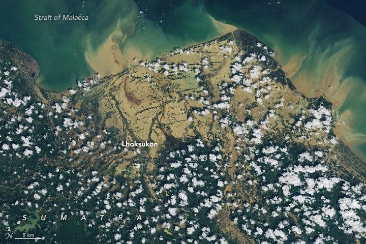
The OLI-2 (Operational Land Imager-2) on Landsat 9 captured this image of flooding in Aceh and North Sumatra provinces on November 30, 2025. Muddy sediment-filled water appears to have swamped much of Lhoksukon, a town of 40,000 people, and several surrounding villages.
Other tropical cyclones and monsoon rains hitting Sri Lanka, Thailand, Malaysia, and Vietnam at roughly the same time have also caused extensive destruction in the broader region. According to one estimate from the United Nations Office for the Coordination of Humanitarian Affairs, flooding has affected more than 10.8 million people in the region and displaced more than 1.2 million.
NASA Earth Observatory image by Lauren Dauphin, using Landsat data from the U.S. Geological Survey. Story by Adam Voiland.
References & Resources
- BNPB (2025) News Index. Accessed December 4, 2025.
- India Today (2025, December 2) What made Cyclone Senyar a once-in-a-century weather anomaly in Malacca Strait. Accessed December 4, 2025.
- The Malaysian Reserve (2025, December 3) Death toll from floods, landslides in Indonesia rises to 811. Accessed December 4, 2025.
- NASA Earthdata (2025) Tropical Cyclones. Accessed December 4, 2025.
- The New York Times (2025, December 3) Where Floodwaters Turned Piles of Timber Into Floating Battering Rams. Accessed December 4, 2025.
- ReliefWeb (2025, December 3) Asia and the Pacific: Southeast and South Asia Cyclones and Floods Humanitarian Snapshot (Covering 17 November to 3 December 2025. Accessed December 4, 2025.
- Tsunami and Disasters Mitigation Research Center (2025, November 29) Extreme Rainfall from Tropical Cyclone Senyar Triggers Widespread Flooding and Infrastructure Damage Across Aceh. Accessed December 4, 2025.