November 19-December 13, 2024
Franklin Fire Leaves Its Mark on Malibu
The Franklin Fire set more than 4,000 acres (16 square kilometers) ablaze in Malibu, California, where it destroyed structures and forced thousands of residents to evacuate their homes.
The blaze ignited on the evening of December 9, 2024, in Malibu Creek State Park. Strong Santa Ana winds fueled its spread to 2,600 acres (11 square kilometers) within a day and extended into the campus of Pepperdine University. At one point on December 10, the fire tripled in size in just one hour, according to Cal Fire.
The OLI (Operational Land Imager) on Landsat 8 and the OLI-2 on Landsat 9 captured these false-color images before and after the inferno ignited. The images combine shortwave infrared, near infrared, and visible light (OLI bands 6-5-4), components of the electromagnetic spectrum that make it easier to identify unburned vegetation (green) and recently burned landscape (dark brown). Charred vegetation was visible on December 13 (right image), when the fire was about 30 percent contained.
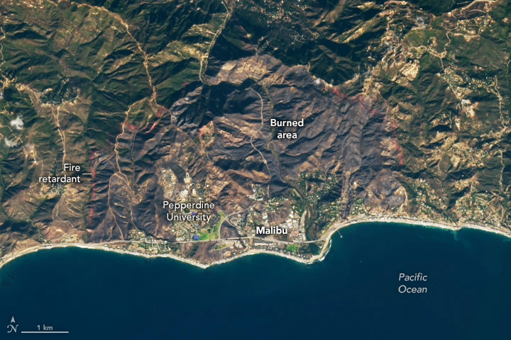
To help slow the fire’s spread, Cal Fire dropped water and red fire retardant from aircraft. A red line of fire retardant is visible along the perimeter of burned vegetation in the natural-color image above, acquired on December 13.
As of December 18, the fire was 89 percent contained and had not seen growth for several days, allowing officials to lift evacuation orders.
References & Resources
- AccuWeather (2024, December 11) Malibu residents flee as wildfire swallows homes along iconic Southern California coastline. Accessed December 18, 2024.
- Cal Fire (2024, December 18) Franklin Fire. Accessed December 18, 2024.
- Cal Fire, via Facebook (2024, December 11) Resources were deployed swiftly in fire suppression efforts, with CAL FIRE airtankers and helicopters delivering over 7,000 gallons of fire retardant and water. Accessed December 18, 2024.
- CBS News (2024, December 13) In Malibu’s Franklin Fire, all evacuations lifted after wildfire scorches over 4,000 acres. Accessed December 18, 2024.
- LAist (2024, December 18) Pepperdine University survived the Franklin Fire and other devastating blazes. Campus officials aren’t surprised. Accessed December 18, 2024.
- Sacramento Bee (2024, December 17) Update: 78% containment reached for Franklin Fire in Los Angeles County. Accessed December 18, 2024.
NASA Earth Observatory images by Wanmei Liang, using Landsat data from the U.S. Geological Survey. Story by Emily Cassidy.