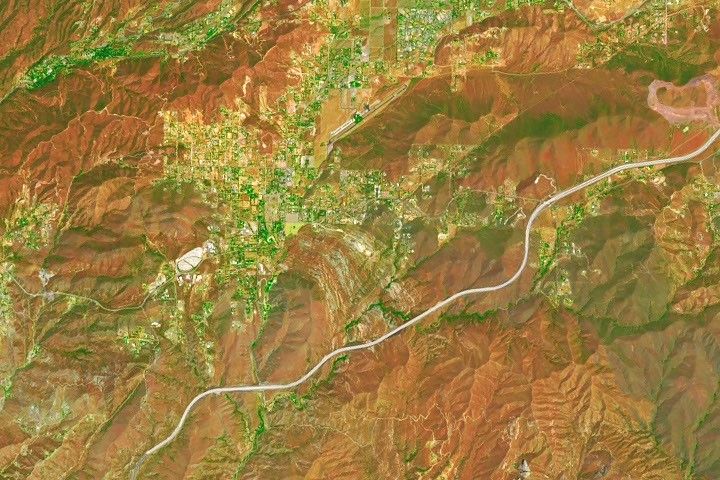
Update on September 8, 2026: This Landsat 9 image shows Vasquez Rocks in California. Read more about the area in our Image of the Day story, “The Otherworldly Geology of Vasquez Rocks.” Congratulations to Dan Richards for being the first reader to identify the location correctly. He did so at 12:59 a.m. ET on September 1, 2026. Read below for the interesting details that the reader Lilambd offered about the area on September 6, 2026. Thanks to everyone who submitted a guess!
----------------------
My guess is Vasquez Rocks Natural Area beside Agua Dulce in northern Los Angeles County, California. The sweeping gray corridor is State Route 14, the long straight feature to the north is the Agua Dulce Airpark runway, and the most distinctive clue is the patch of curved gray stripes at Vasquez Rocks—steeply tilted sedimentary layers shaped by tectonic uplift and differential erosion. The false-color rendering also makes the moister vegetation of the Sierra Pelona appear dark green against the rusty, drier hills around Agua Dulce. NASA’s public image metadata indicates a Landsat Operational Land Imager acquisition on July 28, 2026.
-Lilambd at 3:10 p.m. ET on September 6, 2026
----------------------
Every month, NASA Earth Observatory features a puzzling satellite image. The September 2026 puzzler appears above.
Your Challenge
Identify the location shown in this satellite image. Share what clues you see, where you think it is, and what makes this place interesting or unique to you.
How to Answer
Submit your response using this form and select “Puzzler Answer” as the topic. Please include your preferred name or alias.
You can keep it simple and just guess the location. Want to impress us? Tell us which satellite and instrument captured the image, which spectral bands were used, or point out a subtle detail about the geology or history of the area. If something catches your eye, or if this is your home or means something to you, we’d love to hear about it.
The Prize
We can’t offer prize money or a trip to space to see Earth like satellites and astronauts do. But we can offer something almost as rewarding: puzzler bragging rights.
About a week after the challenge, we’ll post the answer at the top of this page, along with a link to an Earth Observatory Image of the Day story that explains the image in more detail. We’ll recognize the first person who correctly guesses the location, and we may also highlight readers who share especially thoughtful or interesting answers. By submitting a response, you acknowledge that your comments may be edited, excerpted, and published on this page.
Until then, zoom in, look closely, and enjoy the challenge. See you at the reveal!