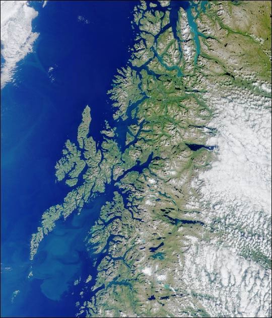
Here’s another chance to play geographical detective! ThisMulti-angle Imaging SpectroRadiometer (MISR) image coversan area measuring 350 kilometers x 415 kilometers, and wascaptured by the instrument’s vertical-viewing (nadir)camera on August 20, 2001. Use any reference materials youlike and answer the following four questions:
- Which nation’s coastline is featured in this image?
- True or False?A large-scale ocean current typically causes winters in this coastalarea to be colder than other locations at the same latitude.
- Which fish play important roles in the lifestyle and economy ofthis coastal region? Choose A, B, or C:
- Tetrapturus audax and Euthynnus affinis
- Gadus morhua and Melanogrammus aeglefinus
- Seriola lalandei and Scomberomorus plurilineatus
- An American author wrote a short work of fictioninspired by a phenomenon associated with the area shown in the lowerleft portion of the image. The story was published in 1841. Who isthe author and what is the title of the story?
E-mail your answers, name (initials are acceptable if youprefer), and your hometown by Monday, October 1, 2001 tosuggestions@mail-misr.jpl.nasa.gov.
Answers will be published on the MISR web site(http://www-misr.jpl.nasa.gov) in conjunction with the nextweekly image release. The names and home towns ofrespondents who answer all questions correctly by thedeadline will also be published in the order responses werereceived. The first 3 people on this list who are notaffiliated with NASA, JPL, or MISR and who did not win aprize in the last quiz will be sent a print of the image.
A new “Where on Earth...?” mystery appears as the MISR#147;image of the week” approximately once per month. A newimage of the week is released every Wednesday at noonPacific time on theMISR home page.The image also appears on theEarth Observatory, andon the Atmospheric Sciences DataCenter home page, though usually with aseveral-hour delay.
References & Resources
Image courtesy NASA/GSFC/LaRC/JPL, MISR Team.