

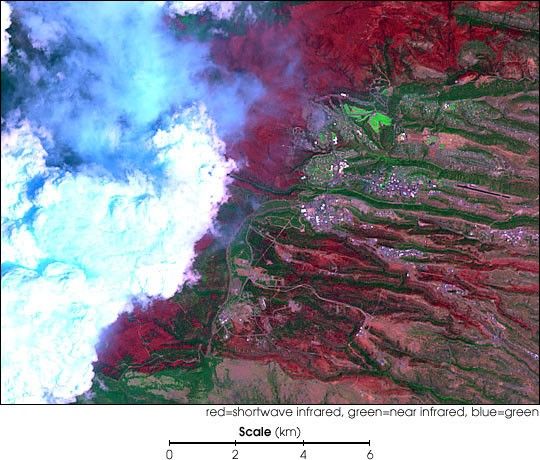
The Cerro Grande Fire near Los Alamos, New Mexico,consumed about 47,650 acres and destroyed more than 200 buildingsduring the month of May 2000. This false-color Landsat 7image shows much of the damage, even though some of theburn scar (red) is obscured by clouds. This scene covers the samearea as the Landsat 7 image from May 9, 2000, previouslydisplayed on the Earth Observatory. (The colors of thisimage are slightly different due to the very bright clouds.)
The extensive damage to the town of Los Alamos (beneath thebright green golf course in the center of the image) andLos Alamos National Laboratory (near the curving road atbottom center) is clearly shown.
Note the surviving vegetation at the bottom of thesteep ravines that run from left to right across the image.High winds caused the fire to jump the ravines withoutdescending into them.
Area residents may be vulnerable to mudslides duringthe rainy season that begins in July. Plants on thehillsides normally hold soil in place and slow water runoff,but after a fire water runs quickly downslope and canerode the bare slopes.
Landsat 7 data are archived and available fromEDC.
References & Resources
Image by Rob Simmon, Earth Observatory, NASA Goddard Space Flight Center. Data courtesy Ron Beck, EROS Data Center (EDC)
None