
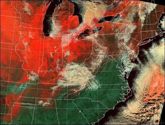
This false-color image shows the current extent of snow cover over thenorth-central and northeastern United States. This scene was acquiredon January 2, 2001, by the Moderate-resolution Imaging Spectroradiometer(MODIS), flying aboard NASA's Terra spacecraft, and processed by theUniversity of Wisconsin-Madison's MODIS direct broadcast receivingfacility.
At visible wavelengths of light (e.g., 0.66 microns), snow cover is asbright as clouds and is therefore difficult to distinguish from cloudcover. However, at near-infrared wavelengths (e.g., 1.6 microns), snowcover absorbs sunlight and therefore appears much darker than clouds.This allows MODIS to discriminate between snow cover and clouds veryeffectively.
In this false-color image, land surfaces are green, water surfaces areblack, snow cover is red, and clouds are white. Those clouds thatcontain a significant fraction of ice particles appear pinkish.
References & Resources
Image courtesy Liam Gumley, MODIS Atmosphere Team, University of Wisconsin-Madison

